Here’s how long it would take to run between Toronto subway stations
Ever wonder how long it would take to run between subway stations in Toronto? We've done the hard work and plotted time on a map based on 5:00 per K pace.
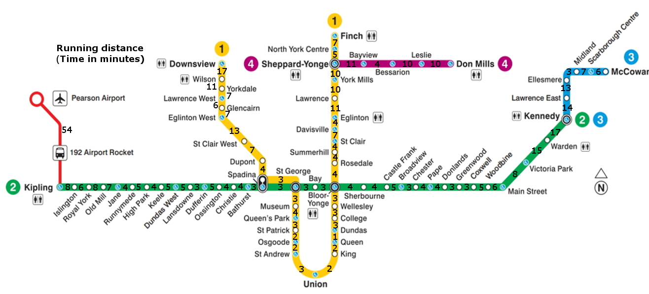
Think you have what it takes keep up with public transit in downtown Toronto? We’ve created a map of subway stations located throughout Toronto and its surrounding areas with the estimated amount of time it would take to run between each, especially handy for run commuters.
Canadian Running used a pace of 5:00 per kilometre and measured the shortest possible distance (either road or pathway) as shown on Google Maps. Note that times were rounded up from half-minutes and down from anything below a half-minute interval for simplicity (4:30 up to five minutes, 4:15 down to four minutes).
RELATED: Where do the top Canadian runners train?
Depending on how fast you go, runners may keep pace with the subway between certain stations, especially if there’s any sort of transit delay. From Spadina to Union, two very popular stations in the downtown area, the distance is approximately 3.7 kilometres by foot.
That distance is covered in about nine minutes if one was take the subway, according to Google Maps, but doesn’t take into account walking from street level to platform level (underground), paying, or foot traffic.
RELATED: Stories from the run commute: “I lost 100 pounds by running to work.”
At 5:00 per kilometre, runners can cover 3.7K in 18:30, or at 4:00 per kilometre (a great workout), it can be done in under 15 minutes, not taking into account traffic lights, detours, and other downtown happenings. Using the tangents and shortcuts may prove to be even quicker.
One of Toronto’s well-known landmarks, Yonge Street, is also a popular route for runners, especially from Finch Station to Bloor-Yonge since there’s little likelihood of getting lost. That run would be approximately 12.5K and is mostly downhill. Unfortunately, transit would only take half as long even at 4:00 per kilometre pace.
Yonge Street hosts a number of road race events in the summer including portions of the Goodlife Fitness Marathon and the Sporting Life 10K.
Click here to see the Montreal Metro runner map and click here to see the Vancouver SkyTrain map for runners.
Check out the latest buyer's guide: