Stay hydrated on Vancouver’s hottest days with map of the city’s water fountains
This Vancouver water fountain map allows runners the ability to plan their routes according to nearby hydration stops across the city.
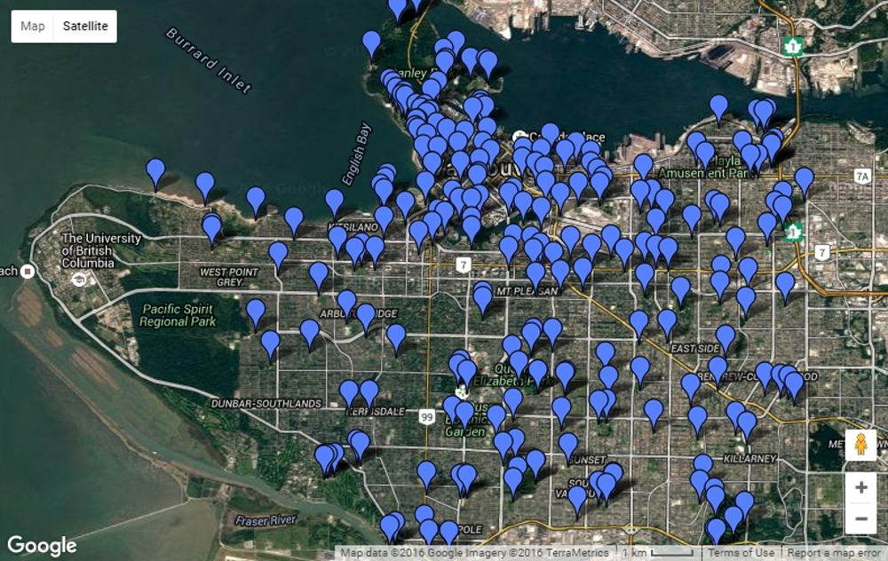
For those hot, summer days in Vancouver, it’s good to have a tab on nearby water fountains in case you’re feeling dehydrated. Fortunately, since Vancouver has a detailed map of every single water station in the city, runners can get creative and plan their route around mid-run pit stop locations.
RELATED: Vancouver’s SkyTrain system mapped out in a runner-friendly way.
For runners in the Point Grey area, the best bet for water foundations is along Spanish Banks and Jericho Beach. In Stanley Park, there are plenty of fountains along the seawall, one of the city’s top running destinations.
The City of Vancouver has a mobile application (TapMap) of all water fountains in the city. The app is available for Android and iOS smartphones.
RELATED: How much do you need to drink – On hydration and performance.
Though it’s an ideal spot for a run, Pacific Spirit Park at the University of British Columbia has a single water fountain though it’s not listed in the above map. Depending on the length of run and the outside temperature, a mid-run water stop may not be necessary. Read Canadian Running‘s article on answers to common questions relating to hydration.
A photo posted by City of Vancouver (@cityofvancouver) on
RELATED: Beat the heat with these proven but rather unusual cooling tricks.
During heatwaves, temporary water stations are set up around the city. Directions to the closest station and more information can be found by clicking on flagged spots on the embedded map. You can zoom and toggle between satellite and plain view on the embedded map at the top of the page.
Many of Vancouver’s trails, including along Northwest Marine Drive and in Stanley Park, can be viewed on Google Maps’ Street View feature. That allows for an interactive, inside look into the terrain and technicality of the trails.
The map does not include water fountains in surrounding areas including North Vancouver and Burnaby because they are a different municipality or city.
Check out the latest buyer's guide: